| Workshops - 17 Hillhouse and CSSSI register day 2 |
|||
|---|---|---|---|
| Time | Event | Instructors | Location |
| Nov 13** 3:00-4:00pm |
Maps, Graphs, & Data Dashboards with Tableau Yale NetID to use computer lab ** (please note this pre-dates the Keynote) |
17 HH,
Room 111
|
Cathy DeRose, Ph.D. and Joshua Dull |
|
Learn how to create interactive data visualizations with only a few clicks. Along with generating individual maps and graphs, we’ll also look at ways to pull visualizations together into a single data dashboard you can publish online using Tableau Public. It’s recommended that attendees request a free, academic license for Tableau Desktop (tableau.com/academic/students). |
  |
||
| Nov 14 10:00-11:00am |
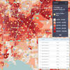
Using SimplyAnalytics for Hyperlocal Research and Analysis SimplyAnalytics is a licensed-database accessible with Yale NetID BYOD or Yale NetID to use computer lab |
CSSSI, Room C27 |
Steven Swartz SimplyAnalytics |
|
Did you know that people in the Hartford, CT DMA are 27% less likely to buy a new vehicle in the next 12 months compared to the entire country but almost 2.5x more likley to own a subaru? Or that residents in NYC are 12.3 % more likey to recyle glass, plastic or paper during the past year? This workshop will include a live demonstration of SimplyAnalytics, a powerful yet user-friendly analytics, data visualization, and mapping application with thousands of hyperlocal demographic, business, marketing & health data variables. With SimplyAnalytics you can answer key research questions, make sound business decisions, and understand the socio-demographic and economic conditions of any geographic area in the United States. |
 |
||
| Nov 14 11:00am-12:30pm |
Primary Research Using Beinecke’s Rare Maps Lecture and map viewing |
Beinecke Library, Room 38 |
Margit Kaye |
|
Yale University has a vast collection of rare maps. Join Margit Kaye on this session to learn how researchers may conduct primary research using rare maps, and start thinking how you could integrate Yale’s most valuable maps and enhance your GIS applications and projects. About Margit Kaye: For many years, students, faculty, and visiting scholars pursuing research in the Yale Library’s Map Collection have relied on the knowledge and assistance of Margit Kaye to navigate Yale’s cartographic resources. She has worked with nearly a half-dozen curators, beginning with the collection’s founder, Alexander Vietor. Quickly assuming principal responsibility for public service at the Map Library, she became a constant source of information about the globes, maps, charts, and atlases that make the Yale collection one of the most significant in the world. In 2005, after the discovery of Forbes Smiley’s thefts of maps from Yale and several other collections in the U.S. and Britain, Margit played an essential role in documenting the damage Smiley caused. (Source: Nota Bene, Vol. xxxI, N. 1, spring 2016.) |
 |
||
| Nov 14 11:30-12:00pm |
Webinar: UCGIS and Yale | CSSSI, Room C27 |
Diana Sinton, Ph.D. UCGIS and Cornell University |
| Yale recently became a member of the University Consortium for Geographic Information Science (UCGIS). This session will present a brief overview of the UCGIS and share opportunities for people in the Yale community. |  |
||
| Nov 14 11:30-1:00pm |
Species Distribution Models (SDM) Using Museum Collections and Citizen Science Data |
17 HH, Room 111 |
Yanina Sica and Charles Marsh |
|
Understanding species’ distributions at regional or global scales may require moving beyond designed studies, which are relatively small scale, to capitalize on museum collections and citizen science projects which represent data spanning entire species ranges. Digitization efforts and open-source observations databases make these occurrence data available. In this hands-on workshop, participants will review the best-practices in mobilizing collections-based and citizen-science data sources for distribution modeling and fit a basic SDM using R programming environment. |
 |
||
| Nov 14 1:00-1:30pm |
Connecting Stories w/StoryMapJS Yale NetID to use computer lab |
CSSSI, Room C27 |
Trip Kirkpatrick |
|
You’ll learn about working with StoryMapJS from Northwestern University Knight Lab. A lightweight, web-based tool, StoryMapsJS allows you to quickly assemble short spatially-grounded narratives. Because projects in StoryMapsJS privilege linear narration (to the degree of displaying a dashed line between points), it can be a quick way to foreground the connectedness of distributed places, events, or other discrete nodes. |
 |
||
| Nov 14 1:30-2:30pm |
Use GDAL/OGR and PKTOOLS for Raster/Vector Operations BYOD or Yale NetID to use computer lab |
17 HH, Room 07 |
Giuseppe Amatulli, Ph.D. |
| The talk will focus on the potential of Open Source Software, such as GDAL/OGR and PKTOOLS, to handling raster/vector operations. Attendees will learn the main bases to start to use this software under the OSGeoLive 13.0 Linux virtual machine. |  |
||
| Nov 14 2:00-3:00pm |
Webinar: Esri StoryMaps Live |
CSSSI, Seminar Room |
Ross Donihue and Greyson Harris Esri |
The Yale StoryMaps Network was recently launched. Join us to attend together an Esri StoryMap Live Event. A live webinar about the latest advances in ArcGIS StoryMaps.
|
 |
||
| Nov 14 2:30-3:30pm |
How to Scam with GIS Yale NetID to use computer lab |
17 HH, Room 111 |
Jill Kelly, Ph.D. |
| Inspired by the classic book “How to Lie with Maps,” this workshop on GIS ethics will empower participants to deconstruct the seeming objectivity of GIS analysis and published maps. |  |
||
| Nov 14 3:00-4:00pm |
Webinar: Leveraging LandScan Global Population Database LandScan is a licensed-database accessible with Yale NetID BYOD or Yale NetID to use computer lab |
CSSSI, Seminar Room |
Jonathan Thompson East View Geospatial, Inc. |
|
LandScan is an award-winning database developed by the Oak Ridge National Laboratory (ORNL) for the United States Department of Energy. Using an innovative approach including complex algorithms, GIS and remote sensing, LandScan measures daytime movements and collective travel habits of all inhabited land mass, generating a better representation of population density during an average day. In this Workshop, Jonathan Thompson will introduce the dataset, and demo the East View Geospatial LandScan Population Data Web Application and Web Services that can be accessed through standard GIS software. |
|||
| Nov 14 4:30-6:00pm |
Using Google Earth Engine for Global Scale Geospatial Analysis BYOD or Yale NetID to use computer lab |
17 HH, Room 111 |
T.C. Chakraborty |
|
This workshop provides a fundamental overview of geospatial analysis using the JavaScript API of Google Earth Engine. We will introduce types of geospatial data, using these data on the Earth Engine platforms, and discuss a host of functionality to visualize and analyze these. This will also allow people with no experience in GIS to explore the range of analytical capabilities of this platform. Particularly, students will learn how to leverage the power of cloud computing to perform geospatial analysis at a global scale. |
 |
||